
It’s National Forest Week— Here Are Some Forests We Can’t Wait to Revisit
National Forest Week runs from July 12-18.

Bruce Burkhardt/Getty
Places like California's Los Padres National Forest are closed through Sept. 17.
The U.S. National Forest System boasts an incredible 193 million acres of wild lands comprising 9,000 miles of scenic byways, 150,000 miles of hiking trails, 4,400 miles of rivers, and 5,100 campgrounds.
With National Forest Week running July 12-18, the staff at Sunset decided to throw together a list of a few forests we can’t wait to get back to. From the picturesque vistas of the Sierra Nevada to the evergreen forests of Oregon, these wild lands are some of the best playgrounds our planet has to offer.
Here are our top picks. Let us know yours!
More Videos From Sunset
SHASTA-TRINITY NATIONAL FOREST, CALIFORNIA
Ed Freeman via Getty
The national forest I keep wanting to return to is Shasta-Trinity. I stumbled upon this one a few summers back when searching for a California cabin getaway. We ended up settling on a place near Bigfoot country, where fishing opportunities were plenty and my camping hammock was (finally) put to good use.
The lakes and rivers are spectacular, places for roadside picnics are everywhere, and if you ever get tired of forest views, the coast is close enough for a good oyster-centric lunch break. (I took many oyster-centric lunch breaks.) — Jennifer Konerman, digital editor
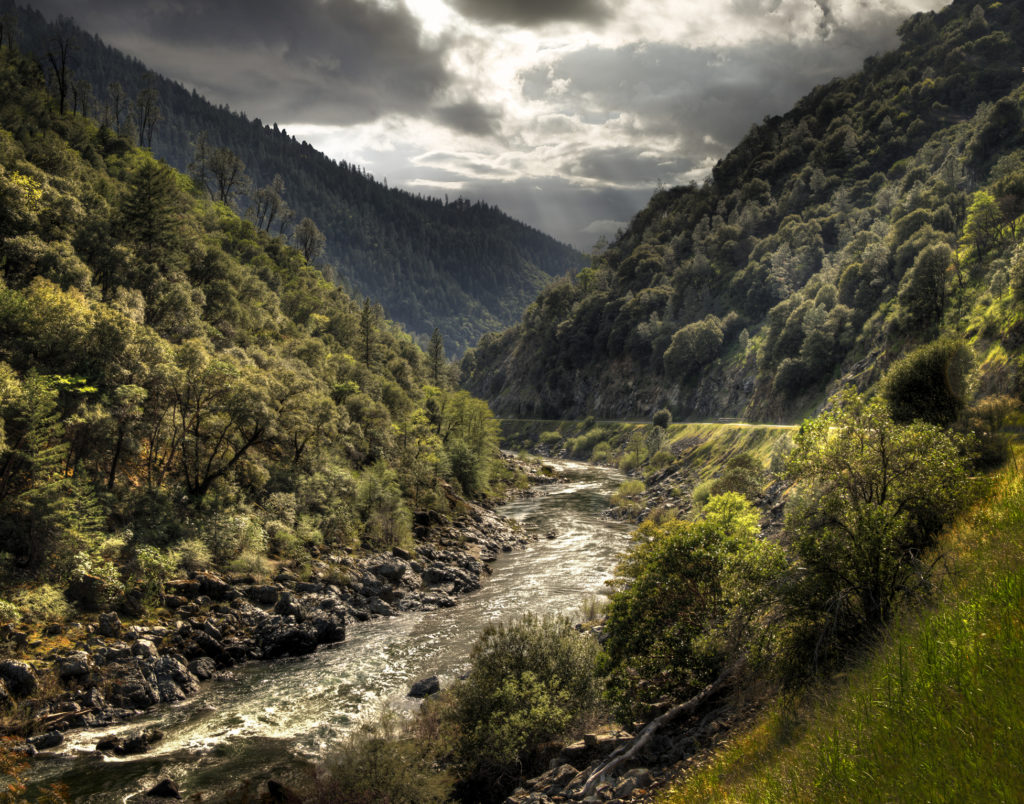
LOS PADRES NATIONAL FOREST, CALIFORNIA

Bruce Burkhardt via Getty
I have the pleasure, and the responsibility, of living part-time at the southeastern edge of the Los Padres, which spans 1.75 million acres, stretches 220 miles from north to south, and covers a sizable chunk of California’s central coast, from the edge of Ojai and Morro Bay to the breathtaking Big Sur coast. There are 1,200 miles of trails that wander through Los Padres, leading to hidden hot springs and gorgeous vistas. I often enter through a trailhead just steps from my door in Santa Barbara County.
The joy comes from reaching Inspiration Point on my regular morning hike and taking in the beautiful views of ocean, sky, and landscape stretching toward the Santa Ynez Valley. Here’s the responsibility: living in a fire-safe way. That means no excess dry brush and debris to catch fire, no stray sparks from a grill blow into the treetops, using water wisely, and avoiding pesticides of all kinds to keep wildlife safe.
There’s been some debate about renaming the land to honor the Chumash tribe that occupied the area for thousands of years before the Franciscan friars—padres—imposed supremacist ideologies up and down the state. But for now, the name remains, and so does its relatively untouched beauty in an increasingly developed world. — Christine Lennon, home and design editor
SIX RIVERS NATIONAL FOREST, CALIFORNIA

Kristin Scharkey/Sunset Magazine
Picture this: It’s just before dusk, and the Smith River is gliding over rocks that glimmer beneath its surface where it cuts through forest in the northwest corner of California. The water is cold enough to cause momentary goosebumps, but not so much so that you can’t wade in for a dip. This is the majesty of Six Rivers National Forest.
The region stretches from the Oregon-California border down to the tip of Mendocino County, a thin strip of nearly 150 miles spanning mountains and valleys—and, of course, the six major rivers that flow through its boundaries.
The Smith River is the “only major undammed, naturally flowing river remaining in California,” according to the Forest Service. Visitors flock to the area for hiking, fishing, rafting, and more. If you’re looking for a quiet spot to stay, Panther Flat Campground offers ample space that’s just a short walk from its banks. Bring your tent and your trail mix. The water awaits. — Kristin Scharkey, senior editor
EL DORADO NATIONAL FOREST, CALIFORNIA
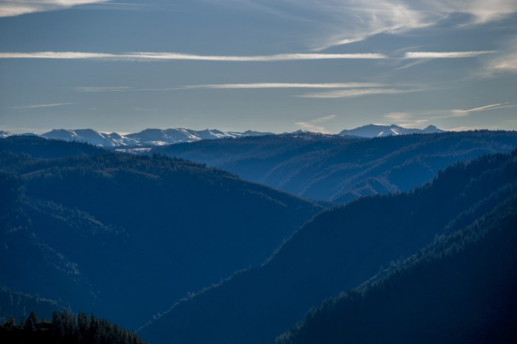
Getty
Many years ago my friend Kristina and I rented a mountain-top cabin in the Desolation Wilderness, which is but one part of the 600,000-acre El Dorado National Forest near Lake Tahoe. We spent a chilly-but-charmed May weekend there. How charmed? One morning we noticed footprints belonging to a large cat in the snow near the cabin and decided they were made by a mountain lion. So, we followed them. (Older and wiser editor’s note: Do not do this.) Luckily, our nearly boundless idiocy was eclipsed only by our poor tracking skills—a happy and harmless ending for everyone involved.
I don’t remember many specifics beyond that, other than it was one of those places where there’s nothing to do, but at the same time, you’re not bored for a second. There was hiking, and the kind of revelatory, deeply satisfying conversations that happen between two people who aren’t old friends yet but are going to be.
Evenings on our little perch at 6,600 feet yielded spectacular sunsets into the Sacramento Valley and crystal-clear starry skies. I haven’t been back since because it would be hard to live up to the memory of that weekend, but someday I’ll return to discover more of El Dorado’s magic. — Nicole Clausing, digital producer
MT. HOOD NATIONAL FOREST, OREGON

J.D. Simkins
While it’s nearly impossible for me to choose a favorite, I recently had the honor of exploring Mt. Hood National Forest. In June, I went with a group for a hike that took us a little over 21 miles along the Pacific Crest Trail.
It didn’t take long to fall in love with the moody Pacific Northwest all over again. Between the scent of pine and abundance of shaggy moss, Mt. Hood National Forest felt otherworldly. — Teaghan Skulszki, editorial intern
WILLAMETTE NATIONAL FOREST, OREGON

J.D. Simkins
My first visit to Bend, Oregon, a little over a year ago left the kind of indelible mark that makes one consider immediate relocation. From the city’s proximity to high desert landscapes like Smith Rock State Park to its northeast to the forests and volcanic landscapes of Umpqua National Forest and Crater Lake National Park to its south, Bend’s charm rests in the diversity of its outdoor playgrounds.
No stops, however, were more rewarding than Willamette National Forest, an ocean of ambrosial Douglas firs, pines, riverside trails and thunderous waterfalls that overload every sense with intoxication. Meandering through the heart of the forest is the McKenzie River, where 1,600 years ago, a lava flow oozing from Oregon’s Belknap Crater smothered a nearly 3-mile stretch that nearly suffocated the river’s flow save for porous rock that, to this day, allows traces of water to seep through in a process that transforms the water into a stunning pool of turquoise.
This is Tamolitch Falls, aptly known as the 30-feet-deep “Blue Pool,” which, due to the water’s deceptive clarity resulting from its unlivable 37°F temperature, appears only 3 or 4 feet deep to the human eye. Its nippy temperatures mean you probably won’t be doing many laps if you do decide to take a dip. Unless, of course, you’re a fan of acute hypothermia. Nevertheless, it’s an oasis worth moving to the top of your bucket list. — J.D. Simkins, WildLands editor
